";
for (let ecoregion of level3Eco) {
items.innerHTML += `
${ecoregion.name}
`;
}
div.insertAdjacentHTML(
"beforeend",
""
);
return div;
};
//requested that legend be hidden, so it's commented out
// level3legend.addTo(map);
// if (params.eco3Show !== true && params.eco4Show !== true) {
// const legend = document.querySelector(".legend-items");
// legend.style.display = "none";
// }
}
/*
*eco3Load* will load the level 3 ecoregion data. Must be TRUE in order for eco3Show to work.
*eco3Show* will automatically populate the map with the level 3 ecoregions. If not selected, the ecoregions & legend will load, but will be toggled off & minimized respectively.
*/
if (params.eco3Load === true) {
//initialize ecoregion layer
const level3Layer = new L.layerGroup();
//add loading spinner while ecoregions load
document.querySelector("#ecoregion_map").insertAdjacentHTML(
"afterend",
`
Level 3 Ecoregions Loading
`
);
const loadLevel3Ecos = async () => {
const promises = [];
for (let eco of level3Eco) {
try {
let res = await fetch(
`https://geodata.epa.gov/arcgis/rest/services/ORD/USEPA_Ecoregions_Level_III_and_IV/MapServer/11/query?where=US_L3CODE+%3D+%27${eco.id}%27&f=geojson`
);
let json = await res.json();
//add ecoregion name so it can be bound to tooltip
json.name = eco.name;
json.style = eco.style;
json.info = eco.info;
promises.push(json);
} catch (error) {
console.log(error);
}
}
Promise.all(promises).then((res) => {
document.querySelector(".spinner-container").hidden = true;
document.querySelector("#level-3-loading").style.display = "none";
for (let ecoregion of res) {
L.geoJSON(ecoregion, {
className: "l3-layer-overlay",
fillOpacity: 0.2,
weight: 1,
color: ecoregion.style,
})
//TODO currently uses unsplash filler images, needs to be updated in future with actual ecoregion pictures
.bindTooltip(ecoregion.name, { className: "ecoregion-popup" })
.on("click", function (e) {
l3sidebar.setContent(`
${ecoregion.name}
Level 3 Ecoregion
${ecoregion.info}
Reference: Griffith, Bryce, Omernick & Rodgers (2007). Ecoregions of Texas.`);
l3sidebar.show();
})
.addTo(level3Layer);
}
//add the layer to the map
if (params.eco3Show === true) {
map.addLayer(level3Layer);
}
//add layer to overlay so it can be toggled
layerControl.addOverlay(level3Layer, "Level 3 Ecoregions");
});
};
loadLevel3Ecos();
//initialize sidebar
const l3sidebar = L.control.sidebar("l3sidebar", {
position: "left",
});
//add controls to sidebar
map.addControl(l3sidebar);
}
/*
*eco4Load* will load the level 3 ecoregion data. Must be TRUE in order for eco4Show to work.
*eco4Show* will automatically populate the map with the level 4 ecoregions. If not selected, the ecoregions & legend (for level 3 ecoregions) will load, but will be toggled off & minimized respectively.
*/
if (params.eco4Load === true) {
//initialize ecoregion layer
const level4Layer = new L.layerGroup();
//add loading spinner while ecoregions load
document.querySelector("#ecoregion_map").insertAdjacentHTML(
"afterend",
`
Level 4 Ecoregions Loading
`
);
const loadLevel4Ecos = async () => {
const lvl4Promises = [];
for (let eco of level4Eco) {
try {
let res = await fetch(
`https://geodata.epa.gov/arcgis/rest/services/ORD/USEPA_Ecoregions_Level_III_and_IV/MapServer/7/query?where=US_L4CODE+%3D+%27${eco.id}%27&f=geojson`
);
let json = await res.json();
//add ecoregion name so it can be bound to tooltip
json.name = eco.name;
json.style = eco.style;
json.info = eco.info;
lvl4Promises.push(json);
} catch (error) {
console.log(error);
}
}
Promise.all(lvl4Promises).then((res) => {
if (params.eco3Load === false && params.eco4Load === true) {
document.querySelector(".spinner-container").hidden = true;
}
document.querySelector("#level-4-loading").style.display = "none";
for (let ecoregion of res) {
L.geoJSON(ecoregion, {
className: "l4-layer-overlay",
fillOpacity: 0.4,
weight: 1,
color: ecoregion.style,
})
//TODO currently uses unsplash filler images, needs to be updated in future with actual ecoregion pictures
.bindTooltip(ecoregion.name, { className: "ecoregion-popup" })
.on("click", function (e) {
l4sidebar.setContent(`
${ecoregion.name}
Level 4 Ecoregion
${ecoregion.info}
Reference: Griffith, Bryce, Omernick & Rodgers (2007). Ecoregions of Texas.`);
l4sidebar.show();
})
.addTo(level4Layer);
}
if (params.eco4Show === true) {
//add the layer to the map
map.addLayer(level4Layer);
}
//add layer to overlay so it can be toggled
layerControl.addOverlay(level4Layer, "Level 4 Ecoregions");
});
};
loadLevel4Ecos();
const l4sidebar = L.control.sidebar("l4sidebar", {
position: "right",
});
map.addControl(l4sidebar);
}
/*
*chapterLoad* will load the chapter location pins & chapter counties to create a "heatmap". Must be TRUE in order for chapterShow to work.
*chapterShow* will automatically populate the map with the chapter location pins & chapter counties. If not selected, the chapter location pins & chapter counties will load but will be toggled off.
*/
if (params.chapterLoad === true) {
const loadChapters = async () => {
const chapterOptions = { ...iconOptions };
chapterOptions.borderColor = "#3c5799";
chapterOptions.textColor = "#3c5799";
chapterOptions.icon = "users";
//initialize layer for chapter pins
const chapterPins = new L.LayerGroup();
//initialize layer for chapter counties
const chapterCounties = new L.LayerGroup();
//storage for chapter counties
const countyArr = [];
//add loading spinner while ecoregions load
document.querySelector("#ecoregion_map").insertAdjacentHTML(
"afterend",
`
Due to its size and geographic location, Texas is unique among states. Covering 266,807 sq. miles, it is second only to Alaska in land area. A large area of land will usually have a great deal of variation in climate and landscapes, factors influencing habitat diversity. The state has impressive topographic diversity, including 91 mountain peaks that are a mile or more high.
Our geographic location is a crossroads where eastern habitats meet western ones and southern subtropical habitats meet northern temperate ones. The annual rainfall can range from eight inches in the deserts of far west Texas to 56 inches per year in the swamps of east Texas.
Ecoregions denote areas of general similarity in ecosystems and in the type, quality, and quantity of environmental resources. Ecoregion frameworks are valuable tools for environmental research, assessment, management, and monitoring of ecosystems and ecosystem components. They have been used for setting resource management goals, developing biological criteria and establishing water quality standards.
The map below references USDA and Texas Parks & Wildlife ecoregion borders.
How to Use Map
Hover over a region with your mouse to see the name of the ecoregion (desktop users only)
Click on the map to open a window with more information about each ecoregion.
Zoom in and out on the map to see which ecoregion you live in.
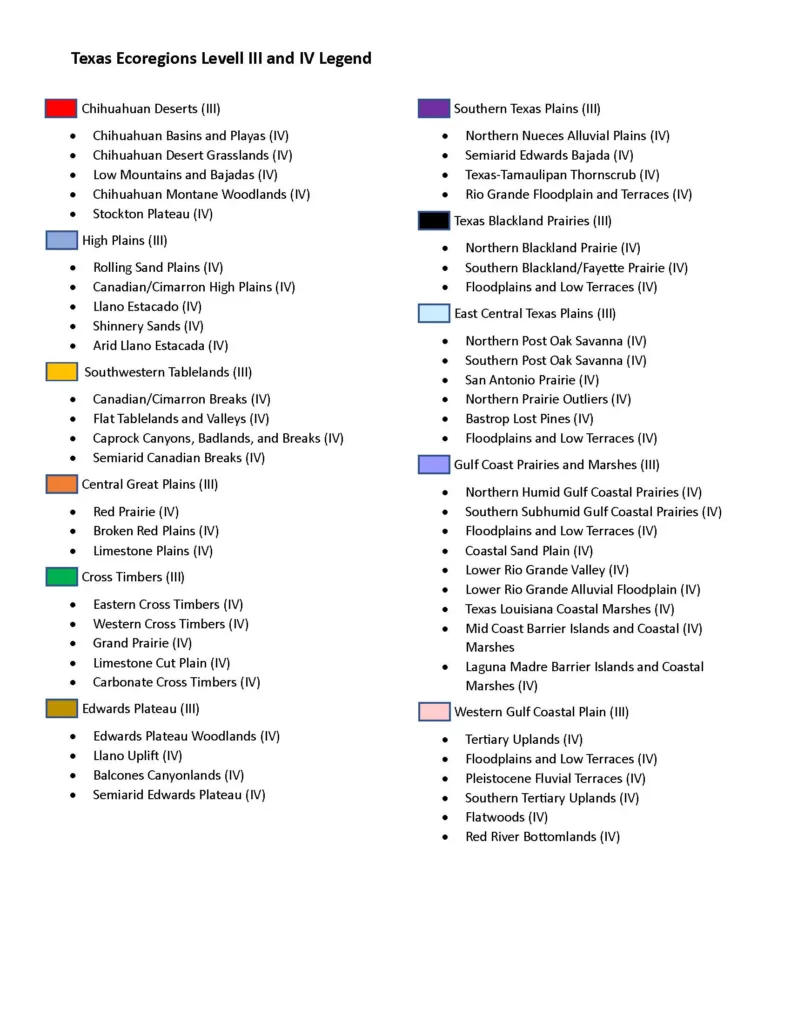
Scroll below for a full legend of all the ecoregions