npsot_bluebonnet_full_color

Mexican Silktassel

Garrya ovata

Other common name(s):

Eggleaf Silktassel, Eggleaf Garrya, Zumaque, Cuauchichic, Cuauchichi, Guachichi

Family:

Garryaceae (Silktassel Family)

Plant Ecoregion Distribution Map

Chihuahuan Deserts, Edwards Plateau
Chihuahuan Basins and Playas, Chihuahuan Desert Grasslands, Chihuahuan Montane Woodlands, Low Mountains and Bajadas, Stockton Plateau
Balcones Canyonlands, Edwards Plateau Woodland

Plant Characteristics

Growth Form

Shrub, Tree

Height

6
to
12
ft.

Spread

3
to
6
ft.

Leaf Retention

Evergreen

Lifespan

Perennial

Habitat and Care Requirements

Soil Type(s)

Limestone, Alkaline

Light Requirement

Sun, Part Shade

Water Requirement

Low

Native Habitat

Grassland, Woodland

Bloom and Attraction

Bloom Color

Green

Bloom Season

Spring

Seasonal Interest

Fruit

Wildlife Benefit

Birds

Maintenance

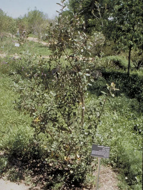
A dense, shrub or small tree. Moderate to fast growing: it has a root system that is slow growing and takes 2-3 years to get well-established. Once established, however, it is moderately fast growing. Very drought tolerant. Needs well drained soil. Typically grows in limestone areas of Central Texas, in the understory of woodland edge. The stems of the male flowers are silky and light green (hence the common name “silktassel”). It is useful as a barrier, foundation hedge, or specimen plant. Typically an understory plant, but can grow in partial sun also. Propagation: seed.

Comments

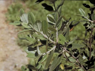
Blooms March-May. A medium-sized shrub or small tree, with dark green oval leaves that are flat or slightly wavy, densely wooly when young, becoming smoother on top and wooly and gray below as they mature. Male and female flowers appear on separate plants. Flowers are green and arranged in hanging racemes. Clusters of small, round, purple fruits appear on females in the fall. Replaces non-native: Ligustrum.

References

1) Griffith, Bryce, Omernick & Rodgers (2007). Ecoregions of Texas. 2) https://www.wildflower.org/plants/result.php?id_plant=GAOV. 3) http://bonap.net/TDC/Image/Map?taxonType=Species&taxonId=12219&locationType=County&mapType=Normal, 4) Native and Adapted Landscape Plants, City of Austin and Texas A&M, 2014, 5) https://www.itis.gov/servlet/SingleRpt/SingleRpt?search_topic=TSN&search_value=27834#null, 6) https://aggie-hort.tamu.edu/ornamentals/nativeshrubs/garryaovata.htm, 7) https://en.wikipedia.org/wiki/Garrya_ovata#:~:text=The%20plant%20is%20usually%20found,some%20authors%20as%20separate%20species:, 8) Jill Nokes (How to Grow Native Plants of Texas and the Southwest)
Receive the latest native plant news

Subscribe To Our News

Subscribe to emails from the Native Plant Society of Texas.

Receive emails when new posts are added 4-6 times per month, or receive an email once a month.

Or join us on social media

About the Region

New Braunfels, the location of our Fall 2024 Symposium, straddles both the Edwards Plateau Ecoregion and the Blackland Prairie ecoregion. Interstate 35 divides the city of New Braunfels; its path through the city closely parallels the boundary of these two ecoregions, with the Edwards Plateau on the west side and the Blackland Prairies region to the east. The Edwards Plateau area is also called the Hill Country; however, this general term covers a much larger area extending farther north. Spring-fed creeks are found throughout the region; deep limestone canyons, rivers, and lakes (reservoirs) are common. Ashe juniper is perhaps the most common woody species found throughout the region. Additional woody species include various species of oak, with live oak (Quercus fusiformis) being the most common. Sycamores (Platanus occidentalis) and bald cypress (Taxodium distichum) border waterways. This area is well known for its spring wildflower displays, though they may be viewed in spring, late summer, and fall, as well. According to Texas Parks and Wildlife, average annual rainfall in the Edwards Plateau ranges from 15 to 34 inches.

The Blackland Prairie extends from the Red River south to San Antonio, bordered on the west by the Edwards Plateau and the Cross Timbers, and on the east by the Post Oak Savannah. Annual rainfall averages 30 to 40 inches, with higher averages to the east. This region is dominated by prairie species. The most common grass species include little bluestem (Schizachyrium scoparium) and Indian grass (Sorghastrum nutans) in the uplands and switchgrass (Panicum virgatum) in the riparian areas and drainages. Common herbaceous flowering plants include salvias, penstemons, and silphiums. This area has suffered greatly from overgrazing and agricultural use. Few intact areas remain, though many of the plants can be found along county roadsides throughout the region.

Our four host chapters (New Braunfels, Lindheimer, Guadalupe, and the Hill Country chapters) are located in one or both of the ecoregions above. However, the eastern portion of Guadalupe County also falls within the Post Oak Savanna ecoregion. Annual rainfall averages 35 to 45 inches, with higher averages to the east. A wide variety of hardwood trees are found, including several species of oaks, elms, and in the Bastrop area, loblolly pine (Pinus taeda). Grasses and forbs dominate in the open savannas, with most common grass being little bluestem. Ranching, agriculture, and fire suppression have allowed woody species to encroach on the once-open savannas.

Source: Wildflowers of Texas by Michael Eason