";
for (let ecoregion of level3Eco) {
items.innerHTML += `
${ecoregion.name}
`;
}
div.insertAdjacentHTML(
"beforeend",
""
);
return div;
};
//requested that legend be hidden, so it's commented out
// level3legend.addTo(map);
// if (params.eco3Show !== true && params.eco4Show !== true) {
// const legend = document.querySelector(".legend-items");
// legend.style.display = "none";
// }
}
/*
*eco3Load* will load the level 3 ecoregion data. Must be TRUE in order for eco3Show to work.
*eco3Show* will automatically populate the map with the level 3 ecoregions. If not selected, the ecoregions & legend will load, but will be toggled off & minimized respectively.
*/
if (params.eco3Load === true) {
//initialize ecoregion layer
const level3Layer = new L.layerGroup();
//add loading spinner while ecoregions load
document.querySelector("#ecoregion_map").insertAdjacentHTML(
"afterend",
`
Level 3 Ecoregions Loading
`
);
const loadLevel3Ecos = async () => {
const promises = [];
for (let eco of level3Eco) {
try {
let res = await fetch(
`https://geodata.epa.gov/arcgis/rest/services/ORD/USEPA_Ecoregions_Level_III_and_IV/MapServer/11/query?where=US_L3CODE+%3D+%27${eco.id}%27&f=geojson`
);
let json = await res.json();
//add ecoregion name so it can be bound to tooltip
json.name = eco.name;
json.style = eco.style;
json.info = eco.info;
promises.push(json);
} catch (error) {
console.log(error);
}
}
Promise.all(promises).then((res) => {
document.querySelector(".spinner-container").hidden = true;
document.querySelector("#level-3-loading").style.display = "none";
for (let ecoregion of res) {
L.geoJSON(ecoregion, {
className: "l3-layer-overlay",
fillOpacity: 0.2,
weight: 1,
color: ecoregion.style,
})
//TODO currently uses unsplash filler images, needs to be updated in future with actual ecoregion pictures
.bindTooltip(ecoregion.name, { className: "ecoregion-popup" })
.on("click", function (e) {
l3sidebar.setContent(`
${ecoregion.name}
Level 3 Ecoregion
${ecoregion.info}
Reference: Griffith, Bryce, Omernick & Rodgers (2007). Ecoregions of Texas.`);
l3sidebar.show();
})
.addTo(level3Layer);
}
//add the layer to the map
if (params.eco3Show === true) {
map.addLayer(level3Layer);
}
//add layer to overlay so it can be toggled
layerControl.addOverlay(level3Layer, "Level 3 Ecoregions");
});
};
loadLevel3Ecos();
//initialize sidebar
const l3sidebar = L.control.sidebar("l3sidebar", {
position: "left",
});
//add controls to sidebar
map.addControl(l3sidebar);
}
/*
*eco4Load* will load the level 3 ecoregion data. Must be TRUE in order for eco4Show to work.
*eco4Show* will automatically populate the map with the level 4 ecoregions. If not selected, the ecoregions & legend (for level 3 ecoregions) will load, but will be toggled off & minimized respectively.
*/
if (params.eco4Load === true) {
//initialize ecoregion layer
const level4Layer = new L.layerGroup();
//add loading spinner while ecoregions load
document.querySelector("#ecoregion_map").insertAdjacentHTML(
"afterend",
`
Level 4 Ecoregions Loading
`
);
const loadLevel4Ecos = async () => {
const lvl4Promises = [];
for (let eco of level4Eco) {
try {
let res = await fetch(
`https://geodata.epa.gov/arcgis/rest/services/ORD/USEPA_Ecoregions_Level_III_and_IV/MapServer/7/query?where=US_L4CODE+%3D+%27${eco.id}%27&f=geojson`
);
let json = await res.json();
//add ecoregion name so it can be bound to tooltip
json.name = eco.name;
json.style = eco.style;
json.info = eco.info;
lvl4Promises.push(json);
} catch (error) {
console.log(error);
}
}
Promise.all(lvl4Promises).then((res) => {
if (params.eco3Load === false && params.eco4Load === true) {
document.querySelector(".spinner-container").hidden = true;
}
document.querySelector("#level-4-loading").style.display = "none";
for (let ecoregion of res) {
L.geoJSON(ecoregion, {
className: "l4-layer-overlay",
fillOpacity: 0.4,
weight: 1,
color: ecoregion.style,
})
//TODO currently uses unsplash filler images, needs to be updated in future with actual ecoregion pictures
.bindTooltip(ecoregion.name, { className: "ecoregion-popup" })
.on("click", function (e) {
l4sidebar.setContent(`
${ecoregion.name}
Level 4 Ecoregion
${ecoregion.info}
Reference: Griffith, Bryce, Omernick & Rodgers (2007). Ecoregions of Texas.`);
l4sidebar.show();
})
.addTo(level4Layer);
}
if (params.eco4Show === true) {
//add the layer to the map
map.addLayer(level4Layer);
}
//add layer to overlay so it can be toggled
layerControl.addOverlay(level4Layer, "Level 4 Ecoregions");
});
};
loadLevel4Ecos();
const l4sidebar = L.control.sidebar("l4sidebar", {
position: "right",
});
map.addControl(l4sidebar);
}
/*
*chapterLoad* will load the chapter location pins & chapter counties to create a "heatmap". Must be TRUE in order for chapterShow to work.
*chapterShow* will automatically populate the map with the chapter location pins & chapter counties. If not selected, the chapter location pins & chapter counties will load but will be toggled off.
*/
if (params.chapterLoad === true) {
const loadChapters = async () => {
const chapterOptions = { ...iconOptions };
chapterOptions.borderColor = "#3c5799";
chapterOptions.textColor = "#3c5799";
chapterOptions.icon = "users";
//initialize layer for chapter pins
const chapterPins = new L.LayerGroup();
//initialize layer for chapter counties
const chapterCounties = new L.LayerGroup();
//storage for chapter counties
const countyArr = [];
//add loading spinner while ecoregions load
document.querySelector("#ecoregion_map").insertAdjacentHTML(
"afterend",
`
June 27, 2023 – 7:00 pm This will be a “hybrid” meeting, attend in-person or online.
In person: The Gathering Center at the Urban Ecology Center at Phil Hardberger Park, 8400 NW Military Hwy
Online: Please register in advance to attend via Zoom.
Presentation by Zachary Tonzetich Butterflies of Bexar County
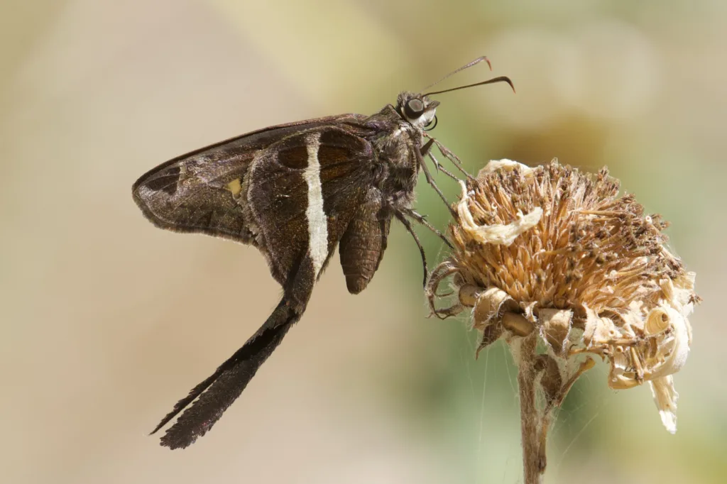
Zachary Tonzetich will discuss some of the basics about how to get started in butterfly watching, describe some identification tips, and share photographs of his personal experiences finding butterflies in Bexar County and some of the native plants that serve as both nectar and larval hosts for butterflies in Texas. This presentation will focus on the more common species found in our area, but will also touch on some examples of rarer species that occasionally show up in Bexar County.
If you are attending via zoom, please register here before the meeting begins as late registration and entry will not be allowed. After registering, you will receive a confirmation email containing information about joining the meeting.
Note: We are limited to 100 participants at the online meeting so some people may not be able to log in with Zoom. You may log in early to make sure the computer is working. If you are unable to attend via Zoom, we will post a recording of the meeting on our YouTube channel for viewing later.