npsot_bluebonnet_full_color

Eurasian Watermilfoil

Myriophyllum spicatum

Other Common Names

Spiked Watermilfoil

Plant Category

Aquatic, Perennial

Invasive Description

Native to Europe, Asia, and north Africa, Eurasian Watermilfoil may have been introduced to the North American continent at Chesapeake Bay in the early 1880s and was first documented in Texas in 1962. Eurasian Watermilfoil is a submersed perennial plant with finely dissected, feather-like leaves and thin stems. Each Eurasian Watermilfoil leaf generally has 14 or more leaflet pairs and this feature can be used most of the time to distinguish Eurasian Watermilfoil from other milfoil species that have whorls of 4 leaves but fewer than 14 leaflet pairs. The tips of Eurasian Watermilfoil that emerge from the water are often red, especially early in the growing season, and these reddish spikes stand several inches above the water and submerge when pollination is complete. Flowers are tiny and pink. There are three native species of watermilfoil in Texas.

Ecological Threat

Eurasian Watermilfoil is an extremely adaptable plant, able to tolerate and even thrive in a variety of environmental conditions. It can form large, floating mats of vegetation on the surface of lakes, rivers, and other water bodies, preventing light penetration for native aquatic plants and impeding water traffic. The plant thrives in areas that have been subjected to various kinds of natural and manmade disturbance. It appears to be primarily spread from waterbody to waterbody through boating activity, although anglers have been known to deliberately plant this species in lakes.

You may not want or need to replace this invasive plant, but if you do, options are listed below.

Eurasian Watermilfoil is on the Texas Dept. of Agriculture’s List of Noxious Plants and on Texas Parks and Wildlife’s list of Invasive, Prohibited and Exotic species which are illegal to sell, distribute or import into Texas.

How to Eradicate

For information on how to eradicate this invasive, view our statement on herbicide use and preferred alternatives for invasive plants.

Native Alternatives

You can replace this invasive plant with native alternatives. Here are some plants that make superior replacements.

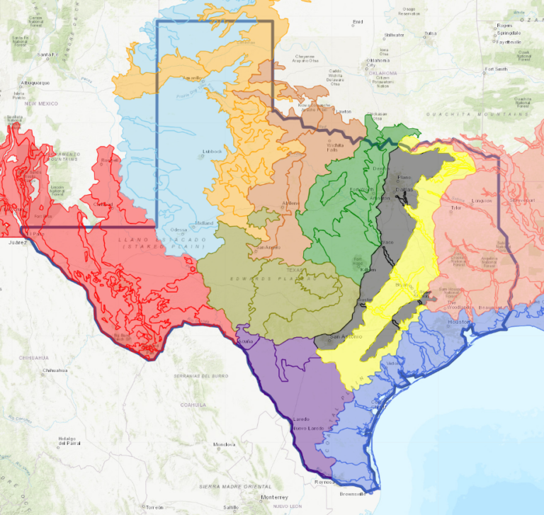
Match your location on the Texas map to the color squares on the replacement plants below to find suitable replacements for your ecoregion.

Click for more details about the ecoregions
Additional Replacement Options: Utricularia radiata, Vallisneria americana
Receive the latest native plant news

Subscribe To Our News

Subscribe to emails from the Native Plant Society of Texas.

Receive emails when new posts are added 4-6 times per month, or receive an email once a month.

Or join us on social media

About the Region

New Braunfels, the location of our Fall 2024 Symposium, straddles both the Edwards Plateau Ecoregion and the Blackland Prairie ecoregion. Interstate 35 divides the city of New Braunfels; its path through the city closely parallels the boundary of these two ecoregions, with the Edwards Plateau on the west side and the Blackland Prairies region to the east. The Edwards Plateau area is also called the Hill Country; however, this general term covers a much larger area extending farther north. Spring-fed creeks are found throughout the region; deep limestone canyons, rivers, and lakes (reservoirs) are common. Ashe juniper is perhaps the most common woody species found throughout the region. Additional woody species include various species of oak, with live oak (Quercus fusiformis) being the most common. Sycamores (Platanus occidentalis) and bald cypress (Taxodium distichum) border waterways. This area is well known for its spring wildflower displays, though they may be viewed in spring, late summer, and fall, as well. According to Texas Parks and Wildlife, average annual rainfall in the Edwards Plateau ranges from 15 to 34 inches.

The Blackland Prairie extends from the Red River south to San Antonio, bordered on the west by the Edwards Plateau and the Cross Timbers, and on the east by the Post Oak Savannah. Annual rainfall averages 30 to 40 inches, with higher averages to the east. This region is dominated by prairie species. The most common grass species include little bluestem (Schizachyrium scoparium) and Indian grass (Sorghastrum nutans) in the uplands and switchgrass (Panicum virgatum) in the riparian areas and drainages. Common herbaceous flowering plants include salvias, penstemons, and silphiums. This area has suffered greatly from overgrazing and agricultural use. Few intact areas remain, though many of the plants can be found along county roadsides throughout the region.

Our four host chapters (New Braunfels, Lindheimer, Guadalupe, and the Hill Country chapters) are located in one or both of the ecoregions above. However, the eastern portion of Guadalupe County also falls within the Post Oak Savanna ecoregion. Annual rainfall averages 35 to 45 inches, with higher averages to the east. A wide variety of hardwood trees are found, including several species of oaks, elms, and in the Bastrop area, loblolly pine (Pinus taeda). Grasses and forbs dominate in the open savannas, with most common grass being little bluestem. Ranching, agriculture, and fire suppression have allowed woody species to encroach on the once-open savannas.

Source: Wildflowers of Texas by Michael Eason